Overview: Interface & Navigation
Use the overview image and table to identify the major areas of the Hub interface.
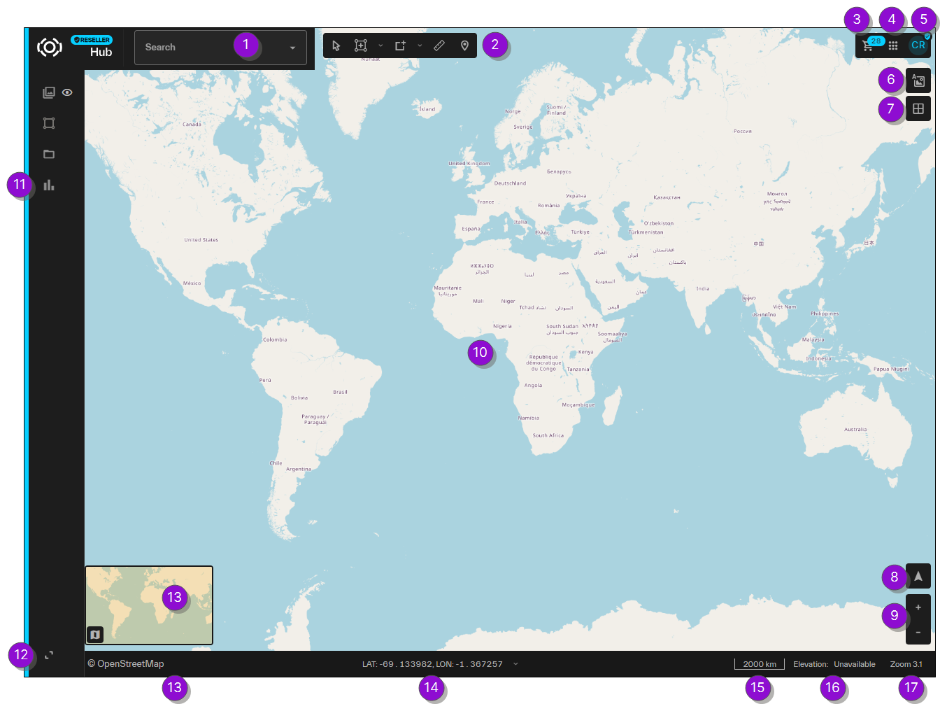
| Numbered Area / Icon | Description | User Guide References |
|---|---|---|
|
1 Search |
Search for and jump to a location. You can search using location names, addresses, or coordinates. |
|
|
2 Workbench |
A toolbar that consolidates map interaction tools (e.g., annotations, area creation, measurement) into a single, organized location. |
|
|
3 Cart |
Access your shopping cart. Use the Cart to open and view, modify, or place pending orders. |
|
|
4 Apps
|
Quickly navigate to other tools, such as the Vantor Hub Administrator Portal |
N/A |
|
5 User Profile Menu |
View your user profile and log out of the system. Set language settings and hide the entire UI. |
|
|
6 Map Labels
|
Add an overlay of roads, city names, and other points of interest to the viewport. | |
|
7 MGRS Grid
|
Toggle the Military Grid Reference System (MGRS) grid overlay. | |
|
8 Map Heading
|
Adjust the map heading. |
Changing Map Heading |
|
9 Zoom
|
Zoom in and out of the viewport. | Zooming and Panning |
|
10 Viewport |
View imagery in this area. |
|
|
11 Side Panel |
Open side-panel tools (e.g., Imagery |
|
|
12 Expand / Collapse |
Expand the sidebar to view each tool's full name and to toggle tools off and on. When the sidebar is expanded, you can collapse it to see more of the viewport. You can also show and hide the UI using the period [ . ] key on your keyboard. |
N/A |
|
13 Minimap and Basemap Selector |
Shows the relative location of the current viewport. As you zoom in on the viewport, the minimap also zooms to show a surrounding region. Select |
|
|
14 Coordinates |
View the map coordinates at your cursor location, and change the coordinate system used in Hub. | |
|
15 Scale Bar |
Adjusts as you zoom in and out, and can be used to determine relative distance. | Zooming and Panning |
|
16 Elevation |
View the elevation at your cursor location. | Viewing Elevation |
|
17 Zoom Level |
Your current zoom level.
|
Zooming and Panning |

 /
/ 
 /
/ 

 /
/ 
 to view or change your basemap. Your current selection is displayed in the bottom navigation bar.
| Numbered Area / Icon | Description |
|---|---|
|
1 Search |
Search for and jump to a location. You can search using location names, addresses, or coordinates. |
|
2 Workbench |
A toolbar that consolidates map interaction tools (e.g., annotations, area creation, measurement) into a single, organized location. |
|
3 Cart |
Access your shopping cart. Use the Cart to open and view, modify, or place pending orders. |
|
4 Apps
|
Quickly navigate to other tools, such as the Vantor Hub Administrator Portal |
|
5 User Profile Menu |
View your user profile and log out of the system. Set language settings and hide the entire UI. |
|
6 Map Labels
|
Add an overlay of roads, city names, and other points of interest to the viewport. |
|
7 MGRS Grid
|
Toggle the Military Grid Reference System (MGRS) grid overlay. |
|
8 Map Heading
|
Adjust the map heading. |
|
9 Zoom
|
Zoom in and out of the viewport. |
|
10 Viewport |
View imagery in this area. |
|
11 Side Panel |
Open side-panel tools (e.g., Imagery |
|
12 Expand / Collapse |
Expand the sidebar to view each tool's full name and to toggle tools off and on. When the sidebar is expanded, you can collapse it to see more of the viewport. You can also show and hide the UI using the period [ . ] key on your keyboard. |
|
13 Minimap and Basemap Selector |
Shows the relative location of the current viewport. As you zoom in on the viewport, the minimap also zooms to show a surrounding region. Select |
|
14 Coordinates |
View the map coordinates at your cursor location, and change the coordinate system used in Hub. |
|
15 Scale Bar |
Adjusts as you zoom in and out, and can be used to determine relative distance. |
|
16 Elevation |
View the elevation at your cursor location. |
|
17 Zoom Level |
Your current zoom level.
|